Brooke Prevedel and Professor Steve Hanna collaborate on “Lafayette’s World” map for Fredericksburg Area Museum
4 min read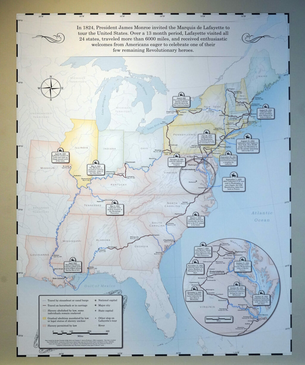
The “Lafayette’s World” map that Prevedel and Professor Hanna created will be on exhibition for two years at FAM. | UMWVoice
by KRISTEN HOWARD
Staff Writer
In 1824, Marquis de Lafayette, who is known for helping write the “Declaration of Rights of Man” as well as fighting in the Continental Army, traveled through 24 states in North America that would one day become part of the greater United States of America. Previously, Lafayette’s passage was not recorded, which is what senior classical archeology and historic preservation double major Brooke Prevedel and Professor of Geography Steve Hanna sought to remedy by creating a map of his journey. The four-by-five map is now on display in The Fredericksburg Area Museum and is part of a two-year exhibit.
Gaila Sims, the curator for African American history and special projects at FAM, brought the idea of creating the map of Lafayette’s journey to Hanna. She described what she wanted to be incorporated into the map from Lafayette’s journey, and Hanna brought in Prevedel to assist.
Creating a map of this size and with intricate details takes time and practice, so Hanna wanted a student who had experience using the software needed to create the map.
“I chose Prevedel to work with me on the project [and] that had to be somebody who already had a great deal of experience in cartographic design and using particular software and other tools to make the map,” he said.
Meanwhile, Prevedel was looking for a new project to work on when Hanna came to her with the idea for the map, as she needed a Geographic Information Science capstone to graduate. She had worked closely with Hanna previously, and the project led to their continued collaboration.
“He brought the idea to me and asked if I wanted to help with the map, and I was so excited to do it. It sounded really interesting and then it just worked out really nicely that the department let me do that project as my capstone,” said Prevedel.
Both Hanna and Prevedel designed maps before “Laffeyette’s World,” and they chose to create this project digitally. According to Prevedel, they used the program ArcGIS Pro to make the base map using data from various sources. This program allows its users to create both 2-D and 3-D maps.
They then used Adobe Illustrator for their post-processing design, which is a popular application that graphic designers use to create vector graphics which are made of points, lines, shapes and curves based on mathematical formulas. Prevedel explained that all of the landmasses, mountains, labeling, water features, color palettes and the making of the route were all done in Adobe Illustrator. According to Hanna, this step involved making the map look like it was produced 200 years ago.
“One of the things that I knew Prevedel was good at because of previous things she had published is that she has a really, really excellent sense of how colors work together … that was one of the parts that she was going to end up focusing on,” said Hanna.
Hanna and Prevedel both emphasized that the colors and styles of drawing certain landscape features, such as mountains, were a large part of producing the map to look like it was created in the 1800s. Taking over 100 hours to create, the main difficulty while working on the map was the color design.
“I think one of the greatest obstacles is just the color design. It’s always very complicated, especially for this one,” said Prevedel. “We had colors that we knew we needed to use because we are working with graphic designers, and so we were trying to make sure our colors matched theirs and worked for the room as a whole.”
Some students at UMW have shown interest in the map, such as Maggie Copeland, a senior historic preservation major who heard about the map through social media. Copeland shared her thoughts about the map.
“It’s incredible to think about how much time [Lafayette] spent traveling, and just the way the map was structured—I guess was really engaging,” she said. “It just stood out to me, the colors in it gave me a good visual cue as to what kind of land he was covering and stuff like that.”
Spending such long hours on one activity or task can create new memories and lessons. Prevedel spoke about some of her favorite and fun memories of creating the map.
“In terms of favorite memories, I honestly think going to the group meetings for the museum was one of the coolest parts of it,” she said. “Just seeing all of these different professionals who you wouldn’t necessarily think are involved in an older museum exhibit.”
Hanna spoke about the memories and exciting moments he experienced while working on the map.
“It is always interesting to be bringing together the stages where we knew what we had to do and we prepared sort of a concept rendering just part of the map. This is how we hoped the mountains would look, this is how the route would look, ” he said. “That to me is a fun moment because you’re exchanging ideas, you’re adapting your vision to work with somebody else’s.”